
Boating Apps Round Up
Thing your tech savvy? Make sure you check out these newest apps for boating this winter!


Route Planner
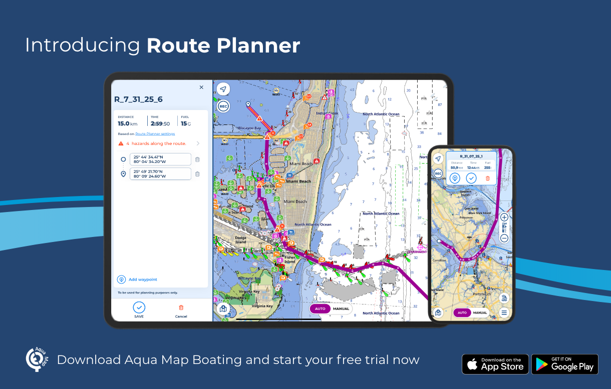
Navigation Made Smarter
The launch of AquaMap’s new Route Planner, a multifunctional route planning tool that offers navigators enhanced control and flexibility, is meant to expand sailors’ resources to help ensure safety and confidence.
By combining Automatic and Manual planning modes, Route Planner allows seamless switching between them within the same route. This hybrid routing capability enables users to customize and combine manual and automatic segments, or fully manual or fully automatic routes, providing precise control.
Key features include:
Automatic and Manual Planning Modes: Seamless switch between manual and automatic planning modes from within the same route.
Existing Tracks: Reference tracks and routes that are visible on your charts as a guide in the creation of new routes.
Hazard Detection: Navigational hazards are automatically identified in both planning modes, remaining visible during active navigation and within the Route Explorer.
Local Data Integration: Incorporate U.S. Coast Guard Data and additional layers such as U.S. Army Corps of Engineers surveys to enhance your route calculation.
Extra Data Overlay: Display overlays from marine forecasts and satellite imagery, tides and currents, community POIs from Active Captain and Waterway Guide.
Quick Search: Easily find and add specific locations, custom markers, or points of interest to your waypoint list.
“We’re looking forward to introducing this update to route planning that gives our users more control, and integrates both Automatic and Manual route planning modes to enhance their planning experience in Aqua Map,” says Enrico Valle, CEO & Co-Founder at GEC srl, developers of Aqua Map. “Route Planner helps navigators make smart decisions with all the essential data in one place to enjoy safer journeys.”
Route Planner is now available to all Aqua Map users. New users can explore any chart subscription and our set of advanced tools with a free 14-day trial (availability may vary by location).
For more information and to download the app, visit www.aquamap.app.
Spot On! Fishing App

There's An App for That
Designed to help anglers plan smarter, fish more efficiently, and explore with confidence, the new SpotOn Fishing mobile app delivers lightning-fast performance, crystal-clear maps, and powerful fishing tools in the palm of your hand. As a leader in future-defining technology for anglers, SpotOn Fishing is thrilled to announce this latest evolution of its fishing platform as well as a few hardware options to coincide the mobile app release. These two hardware options, the Hydros7 Outdoorsman Tablet and Andros 8 Marine Computer are powered by Seatronx and built to give anglers a seamless, professional-level experience on the water.
Available for both Android and iOS, the app delivers instant, lag-free map navigation and high-resolution aerial imagery with 3D shaded relief structure imagery featuring centimeter-accurate data that helps anglers find more fish. The navigation is user-friendly with real time insights and live weather overlays.
For inshore use Pro Aerial Maps are specially processed for clarity even in direct sunlight and allow users to view areas at different tide intervals to navigate shallow waters, choose better routes, and spot vegetation changes. Comparing imagery from multiple sources and times helps uncover subtle shoreline, sandbar, or grass flat shifts that can lead to great inshore opportunities.
Offshore users can use SpotOn Fishing’s offshore structure maps which are uniquely processed to reveal wrecks, reefs, drop-offs, and bottom contours not easily visible on other platforms. Anglers can choose between the Basic High-Resolution Structure option – which taps into NOAA’s latest additions for areas not yet covered by regional Pro Structure Maps – or the Regional Pro Structure Maps, which feature exclusive color palettes that showcase structure like no other. They can also use the Sea Surface Temperature overlay, updated every four hours, to locate temperature breaks that often hold fish, combining these environmental cues with structure detail to identify the most productive zones on the map.
For lake use Pro Lake Structure Maps offer an exclusive visual revealing underwater humps, ledges, troughs, and contour breaks that help anglers avoid seasonal downtime and stay on productive fish year-round. Currently available for select popular lakes, with a growing catalog of expanding coverage, these maps are ideal for reading underwater terrain. When paired with SpotOn Fishing’s multiple aerial map options, users can see vegetation patterns from different time periods on the surface and surrounding areas, then combine that knowledge with the high-resolution 3D structure view of the lake bottom to pinpoint more opportunities.
Cruisers can also take advantage of SpotOn Fishing’s Pro Aerial Maps, which give cruisers the ideal resource for planning and navigating routes in a variety of conditions. Paired with high-resolution 3D structure maps, cruisers can identify underwater features and potential hazards in advance, making route planning more precise. These high-resolution aerial maps can also be saved for offline use, ensuring reliable navigation when traveling in areas without data coverage, and the Navigation Aids overlay provides an extra layer of awareness for more informed cruising.
Finally, SpotOn Fishing keeps anglers and boaters informed with real-time weather overlays that update continuously. Users can toggle rain and lightning layers individually for a clearer view of what matters most to their trip. The high-resolution radar imagery delivers pinpoint detail, while an adjustable opacity slider allows full control over how the weather data appears on the map – making it easy to balance live conditions with the underlying imagery or charts.
The SpotOn Fishing app is the only mobile app that offers fishing tracks designed by the SpotOn fishing team, professional anglers, and the SpotOn Fishing user community. Its library of custom fishing maps and overlays is constantly growing with updates sent directly to a mobile device.
“We’re not just building another fishing app, we’re redefining how anglers and boaters experience the water,” says Nick Gaffney, founder of SpotOn Fishing. “Every update raises the bar, delivering faster performance, sharper imagery, and smarter tools that keep our users ahead of the game. We’re committed to continuous innovation, whether you’re chasing redfish in skinny water, going deep for daytime swordfish, fishing year-round for bass, or simply looking for better imagery and routes for cruising, SpotOn Fishing will always be the most powerful tool at your helm.”
introducing: iNav4U

iNav4U, creators of Zora The Operational System for Yachts, has announced a new collaboration with Aqua Map, a global leader in digital marine navigation.
iNav4U is delivering the first fully integrated, end-to-end platform that unifies yacht management, operations, and navigation in one seamless system. By embedding Aqua Map’s advanced marine charts directly into Zora, captains and yacht owners gain real-time situational awareness and advanced vessel management tools - without juggling multiple apps and devices. The result is a single, intelligent interface that covers every aspect of yacht ownership, from voyage planning and safety to finances and maintenance.
“For too long, captains have had to switch between fragmented systems for navigation, management, and maintenance,” says Olivier Hendrikx, CEO of iNav4U. “By integrating Aqua Maps charts into Zora, we are creating the unified platform the industry has been waiting for—one that makes yacht operations smarter, safer, and simpler.”
With this collaboration, Zora, powered by Aqua Map, becomes the first all-encompassing solution for yachting. Users can now manage navigation, voyage planning, documents, alarms, safety, maintenance, finances, and third-party app integrations—all in one place.
"Captains will welcome this seamless integration, bringing all on-board equipment together on a single screen," says Giorgio Ghiggini, Co-Founder of Aqua Map. "Zora will open a new chapter in marine navigation technology and, for the first time, bring Aqua Map charts to the PC.”
And there’s more to come. Hendrikx and the iNav4U team will unveil a major announcement at the upcoming METS Trade Show in Amsterdam, the world’s largest marine equipment event.