Intracoastal Waterway
The Super Highway of the Water
By Thomas E Dawson
Florida is home to three sections of the Intracoastal Waterway (ICW). The Atlantic Intracoastal Waterway runs along the east coast of Florida and around the Keys. The Okeechobee Waterway cuts across Florida from Port St. Lucie to San Carlos Bay. The southern end of Gulf Intracoastal Waterway begins at the mouth of the Caloosahatchee River and runs up the coast behind the barrier islands to the Anclote River north of Tampa.
Started in the early 1800s, the ICW has grown to include over 3,000 miles of waterways. The purpose of the ICW is to provide commercial vessels with protected waters so they can safely move goods from port to port. To create the ICW natural channels with sufficient depth to support commercial vessels were connected via dredged channels.
The 148-mile stretch of the southern end of the Gulf Intracoastal Waterway was seriously explored in 1935. But funding and construction wasn’t begun until 1960 when coal barges needed a faster and safer route from Tampa to Ft. Myers.
The dredging started in San Carlos Bay where a channel one nautical mile long was channel cut through a shoal in the middle of the bay to create a straight shot across to the river. Dredging through the this shoal created the area known as the Miserable Mile.
To know where the dredged portions of the ICW are you need to look at a chart. NOAA’s Office of the Coast Survey has an online ENC Chart Viewer and a new tool that lets you create custom charts of any area you may want to explore. U.S. Chart No. 1 is also available from NOAA and is a comprehensive guide to the symbols used on the charts.
Many recreational boaters use the ICW to complete the Great Loop around the eastern half of the United States. Florida boaters wishing to take a shorter trip can use the ICW to complete the Mini Loop around the southern half of Florida.
If you are going to travel the ICW here are few things you need to understand. First and foremost, how to read and use the aids to navigation. The aids to navigation aids were designed to support commercial vessels and can be confusing to recreational boaters.
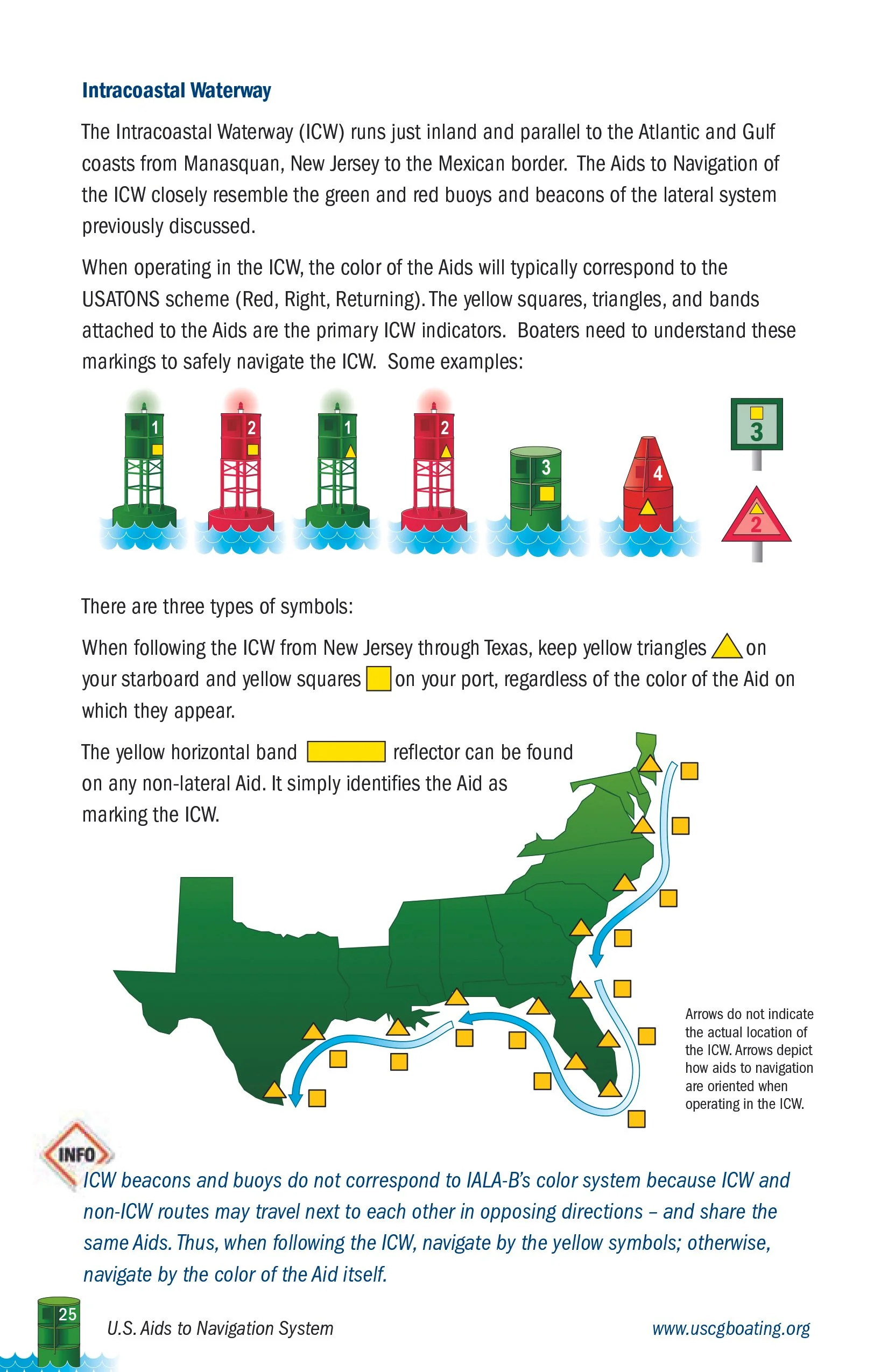
On the ICW the red and green channel markers also have a yellow sticker. As a vessel traveling the ICW you need to treat that aid according to the yellow sticker. A yellow square means you need to pass the aid on the port (left) side of your vessel. A yellow triangle means you need to pass the aid on the starboard (right) side of your vessel.
Since the ICW crosses many other channels there are places where you will see red aids with yellow square stickers and green aids with yellow triangle stickers. Doing otherwise can lead you off the ICW on to another channel or worse run aground. The United States Coast Guard publishes U.S. Aids to Navigation System pamphlet to help you learn to read the signs.
If you are going to cross Florida on the Okeechobee Waterway you need to know the procedures for navigating locks. The Okeechobee Waterway has five locks and the U.S. Army Corps of Engineers, Jacksonville District website has a map of the system, along with a pamphlet called Locking Through Safely.
Finally, if you are looking for some video tutorials on these topics check out America’s Boating Channel. There you will find Introducing ATONS, Navigation Rules FAQ, and Navigating Locks. These videos were produced by the United States Power Squadron and the lock video was filmed at the W.P. Franklin Lock & Dam.
Title photo by Neil Mewes on Unsplash.